Best Easy Hiking Trails Near Eagle Crest
If you’re staying at Eagle Crest and looking for easy outdoor adventures, you don’t have to go far to find great options.
From mellow river walks to scenic ridge trails and paved resort loops, here are the best easy hikes and paths you can enjoy right from the neighborhood, based on our personal experience while living temporarily in Eagle Crest.
Easy Walk to Cline Falls – Central Oregon
Cline Falls on the Deschutes River is a short walk with a beautiful viewpoint just off the Mackenzie Highway, near Eagle Crest resort.
There are a number of places to approach the falls, but we think the view is best from the East side of the river. By parking at the Cline Falls State Scenic Viewpoint parking lot, you can enjoy an easy 0.5 mile walk that passes under the Mackenzie Highway bridge and leads to the waterfalls.
This route has some minor ups and downs but it’s relatively flat. My Dad walked it one month after hip surgery!
The google map is a big misleading, as the Cline Falls State Scenic Viewpoint, located south of the Mackenzie Highway, is not the location of the waterfalls. It’s a picnic area with bathrooms, tables, and parking. There is fishing access and it’s a popular ending point for inner tubing and rafting down the Deschutes.
This is where we parked and started our walk.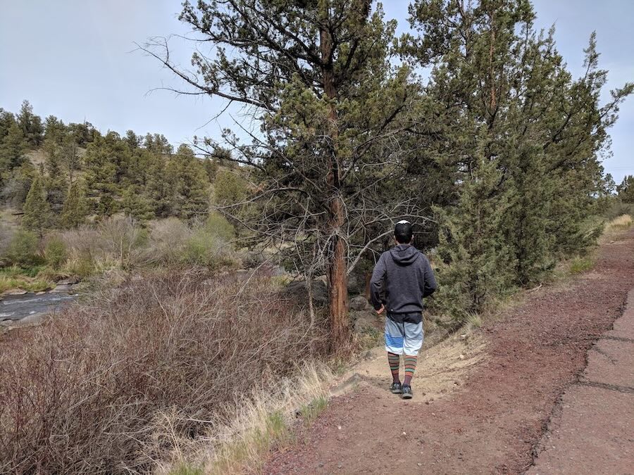
From the picnic area, walk back toward the highway (North) on the road and take one of several dirt paths down to the trail. There were a few paths leading down toward the river, and the second one seemed the most gradual.
There are multiple pathways parallel to the river, and they all end up in the same place. Continue under the bridge.
Once you cross under the bridge, look for a pathway that parallels the river again. You’ll get a bit further away from the water, but not too much.
The falls came up on us almost by surprise because they drop down into the canyon. There are several viewpoints to admire the falls. Because the landscape blends together somewhat, it’s probably more interesting to see the waterfalls in person than in a picture.
If you want to add some distance to your journey, you can continue walking along trails further along the river, toward some houses on the cliff.
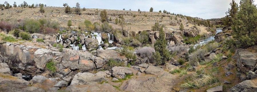
After driving by this spot so many times, it was nice to finally discover these hidden falls for ourselves.
This is not necessarily a “must do” hike, but if you’re in the area and looking for a leisurely walk where you can enjoy natural beauty of Central Oregon, including some interesting rock formations, then this could be a great half hour excursion for you!
Moderate 1 Hour Eagle Crest Hike – Cline Butte Loop Trail
The Cline Butte Loop Trail is an easy-to-moderate hike in Eagle Crest, not far from Redmond, Oregon.
A few residents of Eagle Crest resort walk this one-hour loop for their daily exercise, but the trail is rarely busy. Dogs are allowed on leash.
Visitors are welcome to park in the small gravel area next to the trail head, off of Highland View Loop Road. Note that there are three entrances to this side of the Eagle Crest and the one at Nutcracker Drive and Cline Falls Road requires a resident keycard.
Entrances at Coopers Hawk Drive on the East and Eagle Crest Blvd (off the McKenzie Highway) to the north-west are both open to the public.
There is a dirt road following the power lines to the left of the trailhead – this leads to a barbed wire fence. Instead, follow the path pictured above up the hill.
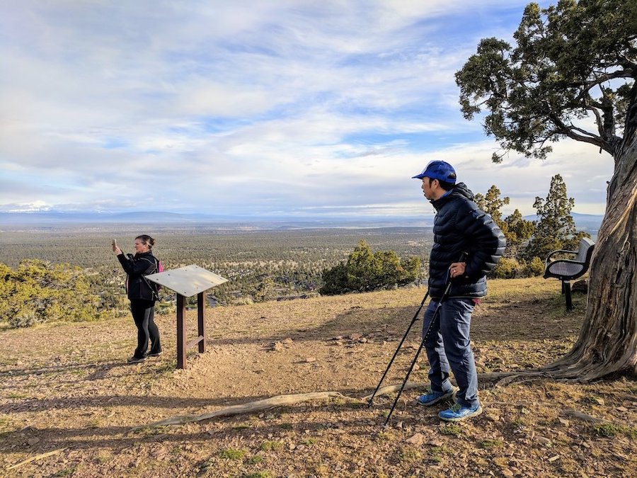
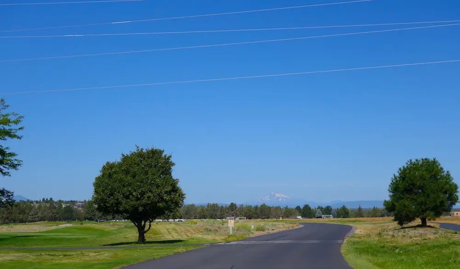
On a clear day, you can see panoramic views of 10 or more peaks, including Three Sisters, Black Butte, Mt. Bachelor, Broken Top, Mt. Washington, Three Finger Jack, Mt. Jefferson, and Mt. Hood. Spectacular!
At the top of the hill, there is a clearing with a bench and a plaque that labels the various mountain peaks. Other parts of the hill are fenced off. Continue on the trail south, downhill.
There are a few steep sections with loose ground, so you may want to proceed with extra caution or use a walking stick. The steep declines are relatively short and minor, so it doesn’t take more than a little bit of careful stepping.
The trail will pass by a handful of nice houses as it continues through the dry, juniper forest. Keep an eye out for deer, rabbits, squirrels, quails and all kinds of other birds!
The dirt trail ends at the trail head by the bend of Highland View Loop. Take a left onto the road, then your first left and first right. In a few yards, you will see a paved trail continuing to the right, off of Highcrest Court.
Walk the paved pathway north. You’ll pass through a nice neighborhood with landscaped common area, following a small creek. After crossing Trail Creek Drive, look for a wide gravel path under the power lines to return directly to the first trailhead and parking area. This 2-mile loop can be completed in less than 1 hour.
Alternatively, you can extend the hike by continuing straight along the paved path, following it toward the lake, pool, and sport center. Then return via road on William Lyche Drive and Highland View Loop.
This hike is best done on a clear day so you can get the full effect of the mountain view. Often, they can be covered in clouds or haze
There is very little shade cover on this hike, so be sure to wear sunscreen and bring water. It’s also wise to wear long pants, as ticks can be found in this area.
Eagle Crest Bike Route Loop Near Redmond Oregon
Eagle Crest Resort, a short drive from downtown Redmond, Oregon, is a great place for family-friendly recreation.
Eagle Crest is a neighborhood with long-term residents and second homes as well as a Central Oregon resort vacation destination with short term rentals, lodge, and conference center.
The resort straddles Cline Falls Road, with sports center facilities and golf courses on both sides. Eagle Crest has easy hikes like Cline Butte loop trail (see details above), the Deschuttes river walk, and Cline Falls (see details above).
The resort also has paved walking trails and wider, paved bicycle paths throughout. Off-road trails for mountain biking are also available in some areas.
Eagle Crest Bicycle Loop Trail Map
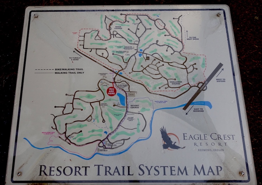
Bicycle loop in Eagle Crest: 7-8 miles
Elevation change: ~450ft
This popular Eagle Crest bicycle route starts at the Lakeside Sports Center off of William Lyche Drive, where there is plenty of parking.
Most of the trails in this part of Eagle Crest are the narrower paths for pedestrians only, though you could certainly bike on the main roads if you wish to add some distance.
The bike trail departs from across the pond and winds through a little valley between neighborhoods. Bikers will need to cross Eagle Crest Blvd, one of the main “thoroughfares” inside the resort.
The bike path follows Eagle Crest Boulevard through a non-residential area until it reaches one of the golf courses.
This loop is mostly flat until the path starts to parallel Cline Falls Road and it makes some dips up and down.
The southern-most part of the loop is one big hill. We prefer to have electric bikes if we do this part, though it’s also great exercise if that’s what you’re looking for.
You can also add on to the loop by crossing near where Falcon Crest Drive meets Cline Falls Road. This will take you past Eagle Crest Lodge and on to the second Eagle Crest Sports Center near the Deschutes River via the wide bike trail that follows Falcon Crest Drive.
While the bike path doesn’t loop around at this end, you could create a loop by following Redtail Hawk and other roads back to the Lodge.
With the many possible extensions to the original loop, you could bike at least 12 miles without retracing your steps much.
>> For more hikes around Redmond, visit our Central Oregon Hikes Overview & Map
>> Looking for a great place to stay in Eagle Crest? See our accommodation recommendations here
We hope this round-up helps you make the most of your time exploring the trails around Eagle Crest. Whether you’re looking for an easy morning walk or a scenic loop to stretch your legs, these routes offer a great taste of Central Oregon’s outdoors. If you’ve tried any of these trails, let us know your favorites in the comments!